


|
 |
|
 |
|
 |
|
 |
|
Great places or events to visit with MapFactor Navigator
Predjama Castle (Slovenia)
This world's largest cave castle is located 9 km from famous Postojna Caves in the Karst area in south-central Slovenia. Built in Renaissance time within a cave mouth in a 123-metre-high cliff it shows how natural elements can seamlessly interwave with manmade ones. In the 15th century the castle became known as the seat of the knight Erazem Lueger, a renowned robber baron. Erazem let enlarge the vertical natural cave shaft, which leads from the castle to the top of the cliff. This allowed him to secretly supply the castle with food in the time of the siege or continue with his robberies.
GPS position: 45°48'57,05"N, 14°7'28,296"E or click this link to show the Predjama Castle location in Navigator. Photo copyright: Dana N.
Falkirk Wheel (Scotland)
The Falkirk Wheel is a unique rotating boat lift (the only of its kind in the world) which raises boats by 24 meters. Located near the town of Falkirk in central Scotland, it connects the Forth and Clyde Canal with the Union Canal. It was opened in 2002 as a part of the Millennium Link project, reuniting the two canals after almost 70 years. GPS position: 56°0'1.2978"N, 3°50'30.213"W or click this link to show the Falkirk Wheel location in Navigator. Photo by Mike Beltzner (Falkirk (Millenium) Wheel) [CC BY-SA 2.0 ], via Wikimedia Commons.
Padjelanta National Park (Sweden)
Padjelanta National Park, established in 1963, is the largest national park in Sweden (1,984km²) and a part of Laponia (UNESCO World Heritage Site).
Located in northern Sweden, it is a vast plateau surrounding two unusually large lakes - the Vastenjávrre lake and the very beautiful Virihávrre lake. GPS position: 67°25'38.1462"N, 16°34'18.6456"E or click this link to show Padjelanta in Navigator.
The Monastery of Ostrog (Montenegro)
The Monastery of Ostrog, part of the Serbian orthodox Church, is located 50 km from Montenegro's capital Podgorica. It is situated against an almost vertical rock face, offering stunning views of the Bjelopavlici plain. GPS position: 42°40'30.7"N, 19°01'47.7"E or click this link to show Ostrog monastery location in Navigator. Original photo published on Flickr by imke.sta, available under CC BY-SA 2.0 licence.
Hinterstoder area (Upper Austria)
Spring in many parts of Alps offers hiking, cycling as well as skiing opportunities. Down in the valleys you can often enjoy beautiful warm spring weather, while you can still ski in the higher parts of the mountains. One such area is the Hinterstoder resort in Upper Austria. GPS position: 47°42'00,50"N, 14°09'25,54"E or click this link to show Hinterstoder in Navigator. Photo copyright: Dana N.
Blue Pools (New Zealand)
The Blue pools can be found on the confluence of the Blue River and the Makarora River in the Mount Aspiring National Park (on the South Island of New Zealand). You can take a short walk from State Highway 6 to a bridge crossing the Blue River and admire the view of the pools and rivers. GPS position: 44°9'59"S, 169°16'18"E or click this link to show Blue pools location in Navigator. Photo by Tomas Kos.
Lednice-Valtice Area (Czech Republic)
The Lednice-Valtice Cultural Landscape in the south-east of the Czech Republic spreads over almost 300 m2. Its landscaping is based on English parks. Here baroque architecture meets the neo-gothic chateau and small follies in the romantic style. GPS position: 48°48'7"N, 16°48'10"E or click this link to show Lednice chateau location in Navigator. Original photo by Peter Toth available under CC0 Creative Commons licence.
Yangshuo and the Li river (China)
One of the most popular tourist destinations in China, the Yangshuo County showcases some of the best scenery China has to offer. Rice fields, distinctive and spectacular karst landforms, romantic views of the Li River and cosy villages can be explored on foot, bicycle or aboard a popular bamboo raft. GPS position: 24°46'42.532"N, 110°29'47,735"E or click this link to show Yangshuo in Navigator. Photo copyright: Iva K.
Essaouira (Morocco)
Essaouira, located on Morocco's Atlantic coast, is a bright and breezy city, the history of which reaches back to prehistoric times. Medina of Essaouira (the old town) is an UNESCO World Heritage fortified seaport from the late 18th century. Its narrow streets are a mix of North African and European styles. Futher interesting facts: Since 1998, the Gnaoua Festival of World Music (dubbed as the "Moroccan Woodstock") is held here, usually in the last week of June, bringing together artists from all over the world. The 3rd series of Game of Thrones was filmed here. GPS position: 31°30'458"N, 9°46'12"W or click this link to show Essaouira in Navigator. Photo by author sachbearbeitung available under CC0 Creative Commons licence.
Piran (Slovenia)
Piran is a town in south-western Slovenia on the Adriatic coast. It has typical medieval architecture, with narrow streets and compact houses and is one of Slovenia's major tourist attractions. The town is the birthplace of composer and violinist Giuseppe Tartini, who played an important role in shaping its cultural heritage and after whom the main square has been named. On the hill above the town stands the Church of Saint George, with a Franciscan monastery nearby. GPS position: 45°31'41,948"N, 13°34'5,84"E or click this link to show Piran in Navigator. Photo copyright: Dana N.
Banff National Park (Canada)
Banff National Park was established in 1885 as Canada's first national park. It is about a one and a half hour drive west of Calgary, Alberta, in the heart of the magnificent Canadian Rockies. Today the park consists of 6,641 square kilometres of mountainous terrain, with numerous glaciers and ice fields, dense coniferous forest, and alpine landscapes. GPS position: 51°30'N, 116°0'W or click this link to show Banff National Park location in Navigator. Photo of Peyto Lake by author med-nunn available under CC0 Creative Commons licence
Škocjan Caves (Slovenia)
The Škocjan Caves are an exceptional system of limestone caves located in the Kras region of south-west Slovenia. Created by the Reka River, they comprise collapsed dolines, some 6 km of underground passages with a total depth of more than 200 meters, and one of the largest known underground chambers, the Martel's Chamber, with a volume of 2.2 million cubic metres. GPS position: 45°39'44"N, 13°59'18"E or click this link to show Škocjan Caves in Navigator. Source of photo: archives PŠJ
Skopje (Macedonia)
Skopje is the capital and the largest city of Macedonia. It is located on the upper course of the Vardar River, on a major north-south Balkan route between Belgrade and Athens. It has a long and colourful history, with Christian as well as Turkish influence. Many churches and mosques can be found here. GPS position: 41°59'47,2"N, 21°25'56,2"E or click this link to show Skopje in Navigator. Photo of Skopje by author Yeowatzup available under CC BY 2.0 licence Date: September 20, 2017
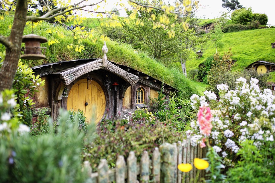
Hobbiton™ Movie Set (New Zealand)
The Lord of the Rings movie trilogy was filmed entirely in New Zealand. Fans can visit the stunning film locations spread over both main islands. A place which shouldn't be missed is the Hobbiton™ movie Set near Matamata (North Island) where you can explore the Hobbiton village. GPS position: 37°52'18,3"S, 175°40'58,7"E or click this link to show Hobbiton™ Movie Set location in Navigator. Photo source: Pixabay.com; Photo author: Masa Hu; available under CC0 Creative Commons licence
St Cyril and Methodius Chapel on Radhošť (Czech Republic)
St Cyril and Methodius chapel (built in 1898) is located on the summit of mountain Radhošť (1129 m), built on a Slavic sacred site to the god Radegast. The chapel is the highest-placed religious building in the Czech Republic. The mountain is a popular destination for pilgrimages and offers fantastic views of the Beskydy mountains. GPS position: 49°29'29,7"N, 18°13'23,2"E or click this link to show Radhošť in Navigator. Photo source/author: Bjalek Michal available under CC-BY-SA-3.0 licence
Wildalpen (Austria)
Wildalpen in Styria (Austria) lies on the river Salza and is a great place for kayaking, canoeing and rafting. There are also many well marked trails in the surrounding mountains and lots of cycling possibilities. GPS position: 47°39'0"N, 14°59'0"E or click this link to show Wildalpen in Navigator. Photo author: Kristina K.
Guinness Storehouse (Dublin, Ireland)
Visiting the Guinness Storehouse® in Dublin is a must for every beer-lover. We wouldn't let you go there without testing it ourselves first. ;-) GPS position: 53°20'30"N, 6°17'13"W or click this link to show Guinness Storehouse® in Navigator. Main photo author: Pertti123 from Pixabay.com; Smaller photo: MapFactor Date: June 1, 2017
The Baku Ateshgah (Azerbaijan)
The Baku Ateshgah is a castle-like religious temple in Surakhgani suburb of Baku. The pentagonal temple complex, built during the 17th and 18th centuries, was used as a Hindu and Zoroastrian place of worship and is often called the "Fire Temple of Baku". GPS position: 40°24'55.59"N, 50°0'31"E or click this link to show Baku Ateshgah in Navigator. Photo author: Kristina K.
Keukenhof (The Netherlands)
Keukenhof is known as the Garden of Europe. Its 32 hectares makes it Europe's largest flower garden. The park is located in Lisse, the Netherlands. GPS position: 52°15'58.5"N, 4°32'59,5"E or click this link to show Keukenhof in Navigator. Date: April 5, 2017
Hoi An (Vietnam)
Hoi An is said to be Vietnam's most atmospheric historic town. Its Old town is an exceptionally well-preserved example of a South-East Asian trading port and since 1999 also a UNESCO World Heritage Site. The covered "Japanese Bridge" dating to the 16th - 17th century with souvenir shops and a pagoda in the center is Hoi An's most favourite sight. Also typically, every evening thousands of handcrafted lanters are lighting up the streets of Hoi An. GPS position: 15°52'37.6"N, 108°19'33.7quot;E or click this link to show Hoi An's Japanese Bridge in Navigator. Photo author: Kristina K.
Chocolate Hills (Bohol, Philippines)
With their almost symmetrical and conical shape the Chocolate hills create an extraordinary landscape unique to the Bohol Island in Philippines.
There are more than 1260 mills spread over an area of more than 50 square kilometers. Their name is derived from the brown colour of the grass at the end of the dry season. GPS position: 9°50'1.3"N, 124°11'52.93"E or click this link to show Chocolate Hills Complex in Navigator. Photo author: Stepan D.
High Tatra Mountains (Slovakia/Poland)
The High Tatra Mountains, situated on the border of Slovakia and Poland, have an alpine character and habitats. 29 peaks reach over 2500 meters. Since 1948 its beautiful nature has been protected as a national park. The High Tatras offer great skiing in the winter and beautiful hikes in the summer. GPS position: 49°07'09.3"N, 20°03'53.6"E or click this link to show High Tatras in Navigator. Photo author: Vladimír Ješko; Source: Pixabay.com; CC0 Creative Commons Licence
Po Nagar (Vietnam)
The Po Nagar Complex lies about 1.5-2 km to the north from the popular Vietnamese summer resort of Nha Trang on the Cu Lao Mountain. This Hindu temple consists of red stone towers and statues created between 7th and 12th century by the Cham kings. GPS position: 12°15'55.4"N, 109°11'37.4"E or click this link to show Po Nagar in Navigator. Photo author: Kristina K.
Dresden Striezelmarkt (Germany)
The Dresden Striezelmarkt is Germany's oldest Christmas market. Its tradition reaches back to year 1434. The market lets you feel the proper Christmas atmosphere including Christmas music, the scent of mulled wine and other traditional Saxon treats. The 582st Dresden Striezelmarkt runs from 24th November to 24th December 2016 at Dresden Altmarkt square. The booths open from 10am to 9pm. More info and programme available here. GPS position: 51°02'58.6"N 13°44'17.4"E or click this link to show Dresden Striezelmarkt in Navigator. Photo © Landeshauptstadt Dresden/Michael Schmidt Date: November 30, 2016
Iguazu Falls (Brazil/Argentina)
Iguazu Falls are stunning waterfalls on the Iguazu River at the border of Brazil and Argentina. They are the largest system of waterfalls in the world, including 275 individual drops. The falls stretch for 2.7 km across and their height varies from 60 m to 82 m. This makes the Iguazu Falls taller than Niagara Falls and twice as wide. GPS position: 25°41'12"S, 54°26'41"W or click this link to show Iguazu Falls in Navigator. Photo author: willian_hludke; Source: Pixabay.com; CC0 Creative Commons Licence
Seville (Andalusia, Spain)
Seville is the capital city of Andalusia. It is one of the largest and most charming cities in Spain. It is famous for its culture, beautiful monuments, traditions and artistic heritage. Did you know that it is the birthplace of Flamenco? GPS position: 37°22'38.9"N, 5°59'12.8"W or click this link to show Seville in Navigator. Photo author: Jacqueline Macou; Source: Pixabay.com; CC0 Creative Commons Licence
Tbilisi (Georgia)
Tbilisi, the capital and the largest city of Georgia, is located on the crossroads of Europe and Asia. Tbilisi's varied history is reflected in its architecture, which is a mix of medieval, classical, Middle Eastern, Art Nouveau, Stalinist and Modernist structures. GPS position: 41°41'16.8"N, 44°48'30.5"E or click this link to show Tbilisi in Navigator. Photo author: Kristina K.
The Signal festival, 13-16 Oct 2016 (Prague, the Czech Republic)
Between the 13th and the 16th October 2016, Prague will be lit up by the Signal festival - The Prague Festival of Lights. Streets and public spaces will be transformed for these four nights under the leadership of Czech and global personalities in light art and design, bringing modern art and new technology to the wider public.
For three years the festival has drawn over a million attendees to Prague streets from all over the world and has become the largest cultural event in the Czech Republic. GPS position: 50°05'26.3"N, 14°24'37.7"E or click this link to show the location of The Prague Signal Dome in Navigator. Photo source/copyright: Signal festival Date: October 4, 2016
Bergen (Norway)
Bergen is the second largest city in Norway. It is located on the Byfjorden (translated as the "city fjord") and is surrounded by seven mountains. With a long trading history the city is an international centre for aquaculture, shipping, offshore petroleum industry and subsea technology.
GPS position: 60°23'47.7"N, 5°19'26.6"E or click this link to show Bergen in Navigator. Photo author: Kristina K.
Planai (Schladming, Austria)
Planai offers a great summer experience for all age groups. Adrenalin-lovers can take a downhill ride using the Mountain-Bike Park, whereas the children will love the Hopsiland at the top station of the Planai cable-car at more than 1800 m. The Panorama Track leading around the top of Planai peak is suitable for all age groups, even with a baby-carriage. GPS position: 47°22'09.1"N, 13°43'33.9"E or click this link to show Planai in Navigator. Photo copyright: Dana N.
The Dachstein Glacier (Ramsau am Dachstein, Austria)
The Dachstein glacier is located on the highest mountain in Styria, Austria at the height of 2700 metres. It is covered by snow all year long, offering a long ski season for 9-10 months of the year. GPS position: 47°28'09.7"N, 13°37'34.3"E or click this link to show the Dachstein Galcier in Navigator. Photo copyright: Dana N. Baku Bay (Azerbaijan)
Baku Bay is a natural harbour of the Azerbaijani capital of Baku, located on the western shore of the Caspian Sea. Its coastline is about 20 km long and the bay spreads over an area of 50 km2. However, the water level has varied significantly over the last 2 millenia, sometimes leaving the bay dry and other times flooded. GPS position: 40°22'29.7"N, 49°51'57.6"E or click this link to show Baku Bay in Navigator. Photo author: Kristina K.
Mastia and surrounding mountains (Georgia)
Mestia, a highland townlet in the Caucasus Mountains on the north-west of Georgia, was an important centre of Georgian culture. The medieval monuments (churches, forts) have been included in the list of UNESCO World Heritage Sites. At an elevation of 1500 meters Mestia is a starting point for many tracks into the beautiful surrounding mountains. GPS position: 43°02'44"N, 42°43'47"E or click this link to show Mestia in Navigator. Photo author: Kristina K.
Rovinj (Croatia)
Rovinj/Rovigno is a beautiful croatian city on the western coast of the Istrian peninsula in the north Adriatic Sea with a strong Roman-influenced history. It is a popular tourist resort with many beaches for day relaxation and a beautiful old town center for evening walks. The old town is situated on a hilly peninsula, offering wonderful sun-set views and the St. Euphemia's Basilica at the top. GPS position: 45°05'00.5"N, 13°37'52.4"E or click this link to show Rovinj in Navigator. Photo copyright: Dana N.
Arena in Pula (Croatia)
The ancient amphitheater in Pula, popularly called the Arena of Pula, was built at the same time as the magnificent Colosseum in Rome in the 1st century AD using the local limestone. Gladiator fights took place here. Today it is used for summer performances - a Film Festival, Opera Season, concerts and even gladiator games exhibitions. Further information available here. GPS position: 44°52'24"N, 13°51'00.6"E or click this link to show the Arena of Pula in Navigator. Photo copyright: Dana N.
Bastei (Germany)
Bastei rock formation and the Bastei sandstone bridge are the major landmark of the Saxon Switzerland National Park, located southeast of the city of Dresden, Germany. The rocks tower to 194 meters above the Elbe River and were formed by water erosion over one million years ago. The present sandstone bridge was built in 1851 and links several rocks for the visitors. GPS position: 50°57'44"N, 14°4'17"E or click this link to show Bastei in the mapFactor Navigator App. Photo author: maxmann; Source: Pixabay.com; CC0 Creative Commons Licence
Alhambra (Granada, Spain)
Alhambra is a palace and fortress complex located in the Andalusian city of Granada. Its name in Arabic recalls the red clay from which the walls of Alhambra are build. The original antient fortress was rebuilt in the mid-13th century by the Moors and after the Christian Reconquista altered to Renaissance tastes and further rebuilt. GPS position: 37°10'37.5"N, 3°35'21.2"W or click this link to show Alhambra in the mapFactor Navigator App. Photo author: Kristina K.
Legzira Beach Arches (Morocco)
Legzira Beach in Morocco is a beautiful beach with several giant red-rock arches. It is possible to walk though some of them when the tide is low. GPS position: 29°26'22.8"N, 10°07'18.0"W or click this link to show Legzira Beach in the mapFactor Navigator App. Photo author: Kristina K.
Tin Mal Mosque (Morocco)
The Tin Mal Mosque has been listed as a UNESCO World Heritage since 1995. It is located in the High Atlas mountains of Morocco. Build in 1156 it commemorates Mohamed Ibn Tumart, the founder of the Almohad dynasty. It is only one of two mosques in Morocco opened to non-Muslims. GPS position: 30°59'06.7"N, 8°13'42.1"W or click this link to show Tin Mal Mosque in the mapFactor Navigator App. Photo author: Kristina K.
Teide National Park (Canary Islands, Spain)
Located in Tenerife, Teide National Park was the 8th most visited national park in the world in 2015. In 2007 the park was added to the list of UNESCO World Heritage Sites. The park comprises almost 19 thousands hectares. The nutrient and mineral rich soil originates from the vulcanic processes and lava flows. GPS position: 28°15'47"N, 16°36'58"W or click this link to show Teide National Park in the mapFactor Navigator App and navigate there. Photo author: Kristina K.
Undredal (Norway)
Norway is famous for its beautiful fjords. Let us inspire you to a visit to Undredal village in Aurlandsfjord. Located about 240 km southwest from Oslo, it has Undredal Stave Church, the smallest stave church in Northern Europe. Undredal is also famous for geitost, a traditional brown goat cheese. GPS position: 60°57'03.0"N, 7°06'09.2"E or click this link to show Undredal in the mapFactor Navigator App and navigate there. Photo author: Kristina K. Adrspach-Teplice Rocks (Czech Republic)
The Adrspach-Teplice Rocks are one of the most popular sandstone rock formations in the Czech Republic. Tectonic and erosion activity formed the rocks into various weird and wonderful shapes and created many gorges you can squeeze through. You can also take a boat ride on a lake surrounded by rocks. The sandstone rock towers with their tens of meters height are very popular with climbers. GPS position: 50°37'00.1"N, 16°07'21.1"E or click this link to find Adrspach in the mapFactor Navigator App and navigate there. Photo author: Sebastian; Source: Pixabay.com; CC0 Creative Commons Licence Pont du Gard (France)
The Pont du Gard is a greatly preserved ancient Roman aqueduct in the south of France, over the river Gard. The bridge with its three tiers of arches is part of a 50-kilometer long system built in the first century AD to carry water to the fountains, baths and homes of the Roman colony of Nimes. The Pont du Gard, at 49 meters, is the tallest of all elevated Roman aqueducts and has been a UNESCO World Heritage Site for more than 30 years. GPS position: 43°56'51,35" N, 4°32'5,75" E or click this link to find Pont du Gard in mapFactor GPS Navigation App and navigate there. Photo author: Frits Kappers; Source: Pixabay.com; CC0 Creative Commons Licence Viareggio Carnevale (Italy)
Viareggio, the main city along the Tuscan coast, hosts in February and March a month-long Carnevale every year. There is a variety of concerts, sports and cultural events, but the main attraction are Sunday's Carnevale parades with lavish floats topped with huge papier-mâché figures moving slowly along the Lungomare promenade. The start of each Carnevale parade is announced by a triple cannon shot. For more details visit http://viareggio.ilcarnevale.com/ GPS position: 43°51'57,4" N, 10°15'12,9" E or click this link to find Viareggio city in mapFactor GPS Navigation App and navigate to Viareggio. Photo source: Carnevalle di Viareggio Date: Feb 18, 2016 The Galapagos Islands (Ecuador)
No dispute, the Galapagos Islands are one of the most beautiful and well-preserved places on Earth. You can visit the Galapagos Island almost any time. Most turists visit the islands in July and August. However, you may want to try between January and May when there is less turists and booming nature. Tip for divers: waters in the spring are said to be clearer and better for diving. GPS position: 0°40'0" S, 90°33'0" W or click this link to see the Galapagos Islands in mapFactor Navigator App. Author/Copyright: Josef Michálek
New Year's Eve in Music City, Nashville, Tennessee (USA)
Nashville, Tennessee, is known as Music City. So if you like music it is an ideal place to spend New Year. Nashville is home to the famous Grand Ole Opry and over 100,000 people join the New Year's celebrations. The headline event is the Bash on Broadway which this year includes the King of Leon. For more details see http://www.visitmusiccity.com/newyearseve. GPS position: 36°10'0" N, 86°47'0" W or click this link to see Nashville in Tennessee in our Navigator App. Photo sourcePixabay.com; Author: Garrett Hill; Licence: CC0 Creative Commons Date: Dec 30, 2015
Sydney Christmas (Australia)
If you prefer sunny weather, spending Christmas in Austrialian Sydney might be a great alternative to the cold north Christmas. There are many Christmas events taking place in Sydney during this time - an interactive Christmas Tree in Martin Place, light projections, choirs in the city and many other events. GPS position: -33°52'3,1" N, 151°12'28" E or click this link to see Martin Place in our Navigator App. Photo source & copyright: City of Sydney Date: Dec 10, 2015
Meet St Nicholas on the streets of the Czech Republic on the 5th of December
Every year, during the evening of 5th December, you can meet St Nicholas together with devils and angels on Czech streets. Adults and young people dress up in costumes and walk through the streets, meet small children, and ask them whether they have been good or naughty. For a short poem or a song the children get some sweets or little presents. The devil accompanies St Nicholas to symbolicly "scare" and "punish" naughty children, the angel to praise good ones. Children usually get some bags behind the window at home either with sweets if they have been good or with some coal and potatoes if they have been naughty. GPS position of the Old Town Square, Prague: 50°5'15" N, 14°25'15,96" E or click this link to see Prague's Old Town Square in our Navigator App. Photo: Mikulas a cert v Praze; Author: Petr Brož; Used under CC BY 3.0 licence
Date: Dec 3, 2015 Viennese Christmas Market and the Magic of Advent (Austria)
The Viennese Christmas Market at Vienna Rathausplatz is celebrating the 30th anniversary of the Magic of Advent. The market is a delight to the senses, full of wonderfull smells and tastes, situated in a magical setting in the heart of Vienna. Have a romantic stroll and enjoy the enchanting atmosphere and the night sky. The Christmas Market 2015 runs from Nov 13 to Dec 26. GPS: 48°12'36.98" N, 16°21'31.6" E or click this link to see Vienna Rathausplatz in our Navigator App. Photo copyright: kreitner & partner Date: Nov 27, 2015
Seven Sisters (the United Kingdom)
The Seven Sisters are naturally occuring chalk cliffs in East Sussex, England, between Seaford and Eastbourne. Visit the Seven Sisters Country Park on the A259 road. They are eroded chalk dry valley on the South Downs. GPS: 50°45'36" N, 0°9'36" E or click this link to see Seven Sisters in our Navigator App. Photo source: Pixabay.com; Author: Diego Torres
Chateau and Natural Park Pruhonice (the Czech Republic)
The romantic Chateau at Pruhonice is located southeast of Prague. You can enjoy a wonderful walk in the surrounding natural park which is a UNESCO World Heritage Site. If you are tired of Prague sightseeing tours, then this is a great place to relax. GPS: 50°0'1" N, 14°33'25" E or click this link to see Chateau Pruhonice in our Navigator App. Photo copyright: Dana N.
Inspired by our Travel tip?Have you been inspired by our Travel tip and visited any of the mentioned places? Let us know what you think or send us a photo. We are always interested in hearing your stories about how you use our Navigator app and interesting places that it has taken you to. If you would like to share your experiences send us an e-mail: navigator@mapfactor.com.
Not using MapFactor Navigator yet?What is MapFactor Navigator:MapFactor Navigator is a free turn-by-turn GPS navigation app for Android or Windows Phones and tablets, with postcodes and free gps maps from OpenStreetMaps. These free maps and postcodes are installed on your device or SD card so there is no need for an Internet connection when travelling. Free Maps are updated every month for free. MapFactor also makes the popular NavigatorFREE GPS navigation software for iOS, PC, Pocket PC and WinCE, also with postcodes and free maps from OpenStreetMaps. OpenStreetMaps are created and updated by the community at www.osm.org. Optional TomTom GPS navigation maps and postcodes are also available. How to get MapFactor Navigator?It is very easy. Free download of MapFactor Navigator is available at Navigator Free website, or directly in App Stores: Google Play, Windows Store.
|


, view of Kl.Priel, Upper Austria")


")


_Wheel.jpg)
9.JPG)
.JPG)